My path:
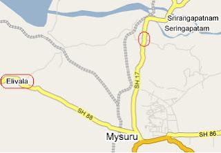
We started afternoon around 1 PM from Bangalore. We took Bangalore Mysore highway. All most all knows that this is one of the best intercity roads in Karnataka. After Srirangapatnam (Before Mysore), we turn right and took “Elivala” Road. To go to “Madikeri ” we no need to touch Mysore. We can save around 10 KM. Once we reach “Elivala” it is very good road like Bangalore Mysore road. Around 150 KMs we need to travel to reach Madikeri. On the way we need to cross Bilikore, Hunsur, kamplalapura, piriyapatna, Kushalnagar…. From Kushalnagar it is bit narrow road. We reached Madikeri by 7:30 PM. It is very good experience to me.
Madikeri lies on the Karnataka State Highway 88 that runs from Mysore to Mangalore. It is 120 km from Mysore and of 252 km from Bangalore.
Place to see

All the above locations are within the MADIKERI town. You can complate all the places in a single day.
We started to mangalore on 9th afternoon and reached by night at 7:30. As it was dasara time we faced problems to get hotel rooms. But finally we got 1 room in “Madicare inn”. It looks good from out side but it is not at all good to stay. We paid 1600/- for 1 night and that room does not have hot water facility, TV… other things.
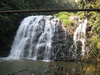
Abbi Water :
We vacated the room on 10th morning and went to Abbi Water falls. From Madikeri the falls are accessible by a narrow road to the coffee estate. A path through coffee and cardamom plantations leads to the waterfalls. The roar of the falls can be heard from the road. The best time to visit is early winter when the monsoons have brought plenty of water.
You won’t get proper food over there. Before going to that place please have some food and go.
We have other places which can be covered in2 to 3 days… that’s depends on your plan.
Cauvery Nisarga Dhama:
It is 28th KMs from Madikeri. It is a bamboo tree garden and the river cauvery will flow from the garden. Nothing much to see. I felt it is just relaxing place.
Harangi Dam:
Around 6km from the Madikeri Kushlanagar Road is the Harangi Dam. It is 38 km from Madikeri. The Harangi river forms a huge reservoir that looks beautiful. It is a nice place for a picnic lunch
Tibetan colony
It is in the Tibetan colony, where Tibetans keep their culture and heritage intact. Dalai Lama visits this temple to offer prayers occasionally.
Dubare Forest
It is 42 kms from Madikeri. Dubare is a forest area, amidst the thriving greenery of Coorg on the banks of river Kaveri, in between Kushalnagar and Siddapur, wherein an elephant training camp of the Forest Department of Coorg is present. This area is populated by the Kurbas, the local tribals. During the period of Maharaja of Mysore, the Dubare reserve forest was used to train the elephants for the impressive Mysore Dussehra festival.
Talacauvery
Talakaveri is the place that is generally considered to be the source of the Kaveri River. It is located in the Brahmagiri hill (not to be confused with the Brahmagiri range further South) near Bhagamandala in Kodagu district, Karnataka, 1,276 m. above sea level. However, there is not a permanent visible flow from this place to the main rivercourse except during the rainy season.